Picture this: sunrise over quiet marsh, an egret lifting off a creek, or a sailboat slipping through the Beaufort River toward Port Royal Sound. In Beaufort, “waterfront” can mean many different things, and each one shapes your day-to-day life. If you’re choosing between riverfront, tidal creek, sound-front, or marsh-view, it helps to understand tides, boating access, permitting, and flood realities before you fall in love.
This guide breaks down your options in plain language so you can match your lifestyle to the right kind of water. You’ll learn how Beaufort’s tides work, what each waterfront type offers, and what to check during due diligence. Let’s dive in.
Beaufort waterfront basics
Beaufort sits where tidal rivers and winding creeks meet Port Royal Sound and the Intracoastal Waterway. The shoreline is mostly salt marsh, with homes overlooking creeks, rivers, and open sound views rather than broad sandy beaches. That marsh network is what gives the Lowcountry its calm, scenic feel.
Tides shape everything here. The NOAA tide gauge in Beaufort shows a mean range of roughly 7.4 feet, which affects dock clearance, exposed mudflats at low tide, and whether a lot has reliable deep water. You should expect regular tidal exposure in creeks and some river margins. Depth at mean low water matters for boats, and the difference between high and low can be significant.
Beaufort’s waters are also rich in life. For a deeper look at the system’s marshes, oysters, and fisheries, the Port Royal Sound Foundation’s overview of Port Royal Sound’s ecology explains why this estuary is so productive. Many buyers prize these views and wildlife encounters as much as quick boat access.
Waterfront types explained
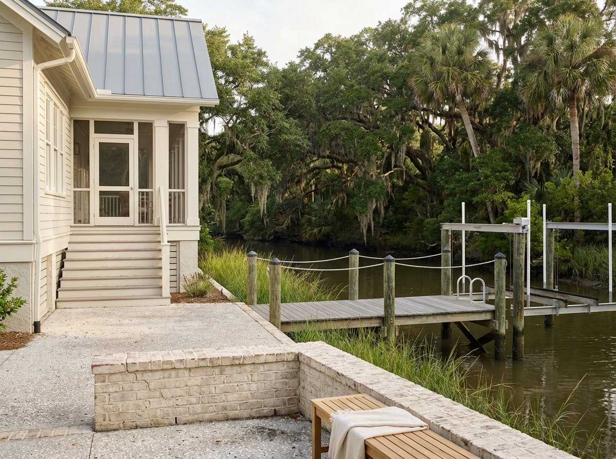
Riverfront and ICW
Riverfront homes face tidal rivers like the Beaufort River or lie along the Intracoastal Waterway. In parts of downtown, you can pair a waterfront view with a walkable lifestyle near shops and dining. If the riverbank fronts a maintained channel or deep slough, it can suit larger boats.
For masted vessels and taller powerboats, check bridge clearances and operating rules. The Coast Guard drawbridge rule for the Woods Memorial Bridge lists a vertical clearance of about 30 feet at mean high water and a set opening schedule. Riverfront lots may need seawalls or living shorelines and can fall within mapped flood zones, so plan for maintenance and insurance.
Good fit for: larger-boat access, quick runs to Port Royal Sound, and in select areas a walkable downtown lifestyle.
Tidal creek frontage
Tidal creeks are narrow, winding channels through the marsh. They are perfect for kayaks, paddleboards, and small skiffs. At low tide, some creeks can be too shallow for larger boats, and dredging may be limited or require permits.
Creekfront living offers close-up wildlife views and a quiet, private feel. You will also see exposed mudflats at low tide and occasional high-tide flooding at the marsh edge. Many buyers love the peaceful setting and lower wave energy compared to open water.
Good fit for: intimate nature views, paddling, and low-impact boating.
Sound-front on Port Royal Sound
Sound-front properties face wider open water, which often means deeper water and bigger views. If you want space for a larger powerboat or a sailboat with fewer daily tidal constraints, sound-front or deep riverfront is usually best. Full-service marinas in this area, such as the Safe Harbor Port Royal Landing marina, provide deep slips and fuel close to Beaufort.
Open-water exposure can bring more wave action and storm surge risk. Shoreline protection and flood insurance are important planning items. If offshore fishing and broad horizons are your priorities, the sound may be your spot.
Good fit for: big-water views, easier navigation to the ocean, and larger-boat flexibility.
Marsh-view and marsh-front
Marsh-view homes sit upland with sweeping views across the marsh to distant channels. Many do not have direct boat access or only support small craft, depending on the marsh between the house and navigable water. Private docks may be limited or require specific permitting.
These properties deliver a signature Lowcountry look: serene views, sunsets, and abundant wildlife. Expect regular tidal change at the edges and the natural sounds of a marsh setting. For many buyers, the tradeoff is worth the scenery and lower maintenance compared with exposed open-water shorelines.
Good fit for: quiet scenery, privacy, and low-maintenance living with limited focus on large boats.
Which lifestyle fits you
- Want offshore or long-range boating: choose sound-front or deep riverfront, then verify depth at mean low water and marina proximity.
- Want calm paddling and wildlife: choose tidal creek or marsh-view, then plan for shallow water at low tide.
- Want a walkable town setting with water views: focus on downtown riverfront near parks and shops, then budget for flood and maintenance.
- Want a second home with simpler upkeep: consider marsh-view or creekfront with a shared community dock or ramp if available.
Each option has tradeoffs. Deep water can bring higher insurance and more shoreline work. Creekfront homes feel sheltered and scenic, but you should be comfortable with exposed mudflats at low tide. Match your boating goals, maintenance comfort, and daily routine to the waterfront type first, then shop specific neighborhoods.
Permits, insurance, and risk basics
Waterfront improvements often involve multiple agencies. Many docks, piers, bulkheads, and dredging projects require review by the U.S. Army Corps of Engineers Charleston District. South Carolina’s coastal program encourages nature-based stabilization when suitable, and the state’s living shoreline guidance outlines options that may be easier on the environment.
Local oyster and reef projects also inform shoreline design and habitat considerations. The South Carolina Department of Natural Resources’ SCORE program documents oyster restoration work and marsh dynamics that can shape what gets permitted along creeks. Understanding these efforts helps you plan a shoreline that fits the setting.
Flood risk is part of any coastal purchase. Use the FEMA Flood Map Service Center to look up your flood zone, and request the most recent elevation certificate during due diligence. Beaufort County uses NOAA scenarios in its planning, and the county’s Sea Level Rise Adaptation report shows how higher tides could change exposure over time.
Utilities matter, too. Some waterfront homes are on septic, while others connect to public sewer. Confirm whether your property is served by the Beaufort-Jasper Water & Sewer Authority or if sewer expansion is planned in the area, since that can affect costs and future improvements.
What to check before you tour
Use this quick checklist to make smart comparisons across properties:
- Ownership and access
- Ask for any recorded dock or pier permits and easements. Confirm whether HOA covenants restrict dock construction or use.
- Boating and navigation
- Request measured depths at mean low water and mean lower low water. Ask for recent depth soundings or a hydrographic survey if boat size is a priority.
- Confirm bridge clearances and schedules for your route, including the Woods Memorial Bridge operating rule if you plan to pass beneath it.
- Flood and elevation
- Pull a FEMA FIRMette for the parcel, note the flood zone, and request the latest elevation certificate. Ask the seller about any flood history and claims.
- Shoreline work and ecology
- If a dock or seawall exists, request copies of the USACE and state critical area permits and any maintenance records. Ask whether prior work used living shoreline methods or hard structures.
- Septic and utilities
- If on septic, obtain the most recent inspection and identify the drain field location. If public sewer is available or planned, ask BJWSA for confirmation and timing.
- Risk and context
- Ask for storm damage history, prior dredging cycles, and nearby marina or public ramp activity that may affect noise and privacy.
- Professional evaluations
- Order a coastal or marine survey for shoreline structures, a land survey noting mean high water and the critical line, and septic inspections where needed.
Local touchpoints to explore
- Downtown Beaufort’s riverfront park area offers a clear picture of riverfront plus town access, with a front-row seat to the Beaufort River and the Intracoastal Waterway.
- Port Royal’s Sands area gives you a feel for open-water exposure and direct routes to the Sound. For services and deep slips, the Safe Harbor Port Royal Landing marina sits close to many neighborhoods.
- Lady’s Island and the surrounding Sea Islands show classic tidal-creek and marshfront living, where quiet coves and wildlife define the daily rhythm.
Next steps
Choosing your Beaufort waterfront lifestyle starts with clear goals: how you plan to boat, how much maintenance you want, and how you picture your day by the water. Once you hone that vision, the right homes and neighborhoods come into focus fast. If you want a local guide to help you match tides, access, and permitting to your dream property, we are here to help.
Reach out to the Chambers Helms Group to explore options, tour the right waterfronts for your goals, and move forward with confidence.
FAQs
What does “deep water” mean in Beaufort?
- Deep water typically means enough depth at mean low water to float your boat safely and access a navigable channel without timing every trip to high tide. Always verify measured depths at the dock and along the route.
How do Beaufort’s tides affect boat access?
- With a mean tidal range of roughly 7.4 feet, creeks can be shallow or even expose mudflats at low tide while river or sound channels stay navigable. Plan dock height, ramp angles, and departure times around the tide cycle.
Do I need flood insurance for a waterfront home?
- It depends on your FEMA flood zone and lender requirements, but waterfront parcels often fall in higher-risk zones. Check the FEMA Flood Map Service Center and request the latest elevation certificate early.
Can I build or expand a dock on my property?
- Many dock projects need approvals from the U.S. Army Corps of Engineers Charleston District and the state coastal program, which encourages nature-based solutions where appropriate. Ask for existing permits and consult a local marine contractor early.
What is a “living shoreline,” and is it allowed?
- A living shoreline uses plants, shell, or low-profile structures to stabilize banks while supporting habitat, and South Carolina promotes it when conditions fit. Review the state’s living shoreline guidance and get site-specific advice.
Will the Woods Memorial Bridge affect my boating route?
- If your vessel’s air draft approaches 30 feet at mean high water, plan around the bridge’s operating schedule and clearance. For smaller boats, it is usually a non-issue.